
Our History
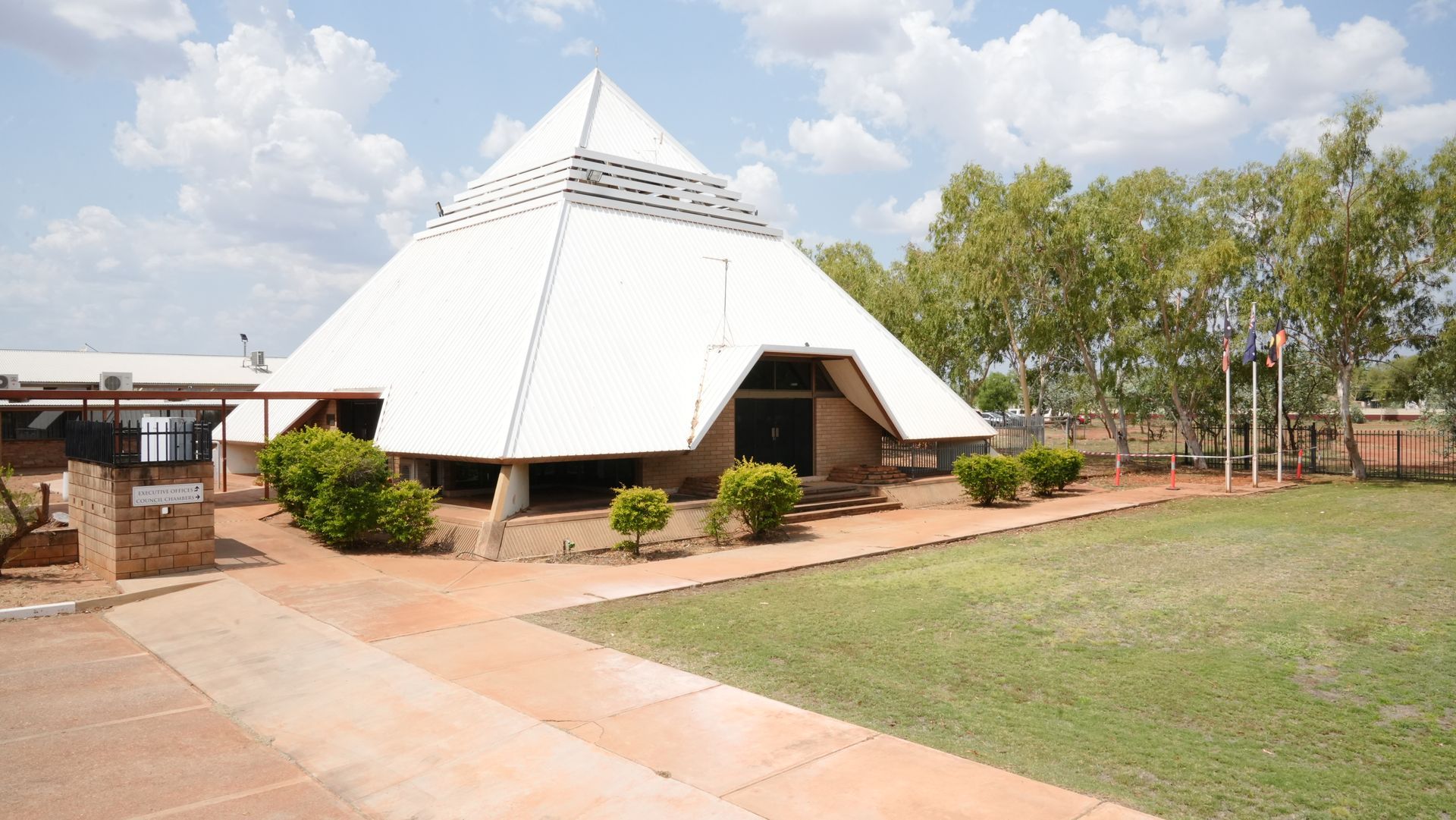
Our Story
In October 2006 the Northern Territory Government announced the reform of local government areas. The intention of the reform was to improve and expand the delivery of services to towns and communities across the Northern Territory by establishing eleven new super shires.
The Barkly Shire Council was created on 1 July 2008 as were the remaining ten shires. Barkly Shire became the second largest Local Government area in Australia at 323,514km², after East Pilbara shire in Western Australia at 380,000km².
Following a review of Local Government, the Northern Territory Government announced that amongst other changes the name “Shire Council” would be changed to “Regional Council” in the eight large Northern Territory Shires.
Council agreed to introduce this change on the 1st January 2014. This marked the start of a new era for the Barkly Regional Council.
The Northern Territory Government also flagged increasing the responsibility of Local Authorities, formerly known as Local Boards, in representing local communities and Towns. The name change and the change in Local Authorities reflected a growing sophistication and acknowledgment of the developing regional responsibility of the Barkly Regional Council.
The Barkly Regional Council is divided into four wards, and is governed by a Mayor and 12 Councillors:
- Alyawarr Ward (4)
- Patta Ward (5)
- Alpurrurulam Ward (1)
- Kuwarrangu Ward (2) - *Formerly known as Yapakurlangu Ward. The new ward name was gazetted by the NT Government in 2016.
Council Wards
Changes to the internal ward boundaries of Barkly Regional Council in effect from March 2012 included a new ward named Alpurrurulam, which brought the total elected members from 12 to 13, including a popularly elected President.
In accordance with section 9 (2) of the Local Government Act changes were actioned via a NT Government Gazette notice – Alpurrurulam Ward 2 Feb 2012.
In 2015 Barkly Regional Council endorsed the ward name change from Yapakurlangu to Kuwarrangu. This change was gazetted by the NT Government in 2016.
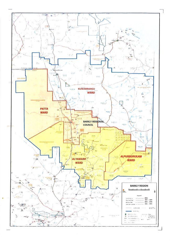
Localities within the four wards are as follows:
PATTA WARD
Blue Bush, Hingston's Place, Junkaji, Kalinjarri, Kargaru, Kalumpurlpa, Kumunu, Karlinjaringi, Kurraya, Likkaparta, Marla Marla, McLaren Creek Station, Mungalawurru, Mungkarta, Munji-Marla, Murtulki, Napagunpa, Ngalpa Ngalpa, Ngurrutiji, Nguyarramini, Nuradidgee, Pakulki, Phillip Creek Station, Pingala, Puawua, Punjarriji, Tennant Creek, Tingkarl, Wiitin, and Wuppa.
ALYAWARR WARD
10 Mile, Ali Curung, Amengernterneah, Ammaroo Station, Ampilatwatja, Ankerrapw, Arapunya Station, Annerre, Arawerr, Arlparra, Arrawajin, Arnerre, Artekerr, Atheley, Atnarara, Atneltyey, Atnwengerrpe, Atheley, Barrow Creek, Camel Camp, Canteen Creek, Delmore Downs Station, Derry Downs Station, Elkedra Station, Epenarra, Hatches Creek, Illeuwurru, Imangara, Imperrenth, Indaringinya, Inkawenyerre, Inkwelaye, Irrultja, Iylentye, Jemelke, Kalpitapta, Kunayungku, Kurundi Station, Kurinelli, Miyikampi, Murray Downs Station, Neutral Junction Station, Ngappamilarnu, Ngkwarlerlanem, Panjirriji, Partnparinji, Pungalindem, Purrukuwurru, Singleton Station,Tara, Tommyhawk Swamp, Wakurlpu, Wauchope, Welere, Wunara, Wutunugurra and Wycliffe Well.
KUWARRANGU WARD
Alexandria Station, Alroy Downs Station, Anthony Lagoon Station, Arruwurru Station, Austral Downs Station, Avon Downs Station, Bajaminyi, Banka Banka Station, Barkly Homestead, Beetaloo Station, Benmarra, Bootu Creek, Brunchilly Station, Brunette Downs Station, Burrumburru, Burudu, Connells Lagoon, Corella Creek, Elliott, Gallipoli Station, Gulunguru, Gumuluji, Gurungu, Helen Springs Station, Iluwurru, Jangirulu, Jilundarina, Jingaloo, Kulumpurlpa, Kurntapurra, Lija Mukumparla, Mallapunyah Springs Station, Marlinja, Mittiebah Station, Muckaty Station, Mungabroom Station, Murranji Station, Murun Murula, Namerinni, Newcastle Waters, Ngunarra, Ngurrara, Nudjabarra, Powell Creek Station, Renner Springs, Rockhampton Downs Station, Soudan Station, Ucharonidge Station, Walhallow Station,Wangalinji, Wilyuku and Wogyala.
ALPURRURLAM WARD
Alpurrurulam community, Argadargada Station, Annitowa Station, Lake Nash Station, Irrmarne, and Ooratippra Station.
Our Logo
In 2008 Shire Transition Committee members worked closely together to choose from several different designs by three artists from the Papulu Apparr-Kari Aboriginal Corporation in Tennant Creek.
The logistics for creating and selecting a logo was extremely difficult simply because of the sheer size of the region, but a design called Tracks of the Barkly by Barbara Whippy using the previous smaller community councils’ logos captured the spirit of the region.
For the committee members a footprint has no colour and humanity has to be there. They felt that there were these visual tracks right across the Barkly region, which referred to a diversity of people living in the Barkly over time: Indigenous, non-Indigenous, miners, and those men and women working in the cattle industry.
The base line for the logo is the “McDouall Ranges” north of Tennant Creek, named by John McDouall Stuart on Tuesday, 5th June, 1860. This was in honour of Colonel James McDouall, of the 2nd Life Guards, Logan and Wigtownshire.
Locally they are known as the “Honeymoon Ranges” so called by the newlyweds camping on their mining leases in the range during the 1930s gold rush.
Above, there is a row of symbols starting with the Sandover Lily which represents the Urapuntja or Utopia region, the Lizard which symbolises Nyinkka, a sacred symbol in Tennant Creek, and Emu which characterises Elliott and the surrounding region.
The footprint in the centre represents humanity – all of the people of the Barkly – with the Bat representing Alpurrurulam, Kangaroo characterising Ampilatwatja and Dingo a sacred symbol for Ali Curung.
The Tracks of the Barkly logo shows that Barkly Regional Council as represented by the Council laws are listening to the communities and to the people of this vast remote region, not only with their intellects but with their hearts.