
Communities
Ali Curung
Council Contact
Mail : Community Mail Bag 188 Ali Curung, via Alice Springs NT 0872
Local Authority
CHAIR:
VACANT
DEPUTY CHAIR:
VACANT
APPOINTED MEMBERS:
Ethan Wilson, Camus Campbell , Anna Rice, Peter Corbett, Ned Kelly, Jerry Rice, Lucy Jackson
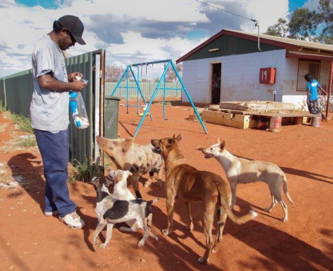
The term Ali Curung is a Kaiditch (Kaytetye) word meaning country of the dogs, dog area, or dog dreaming. LA Meetings are subject to change, so please call the Area Manager to check dates.
"The dogs here at Ali Curung are very important. They are connected to the ancestors. The ancestor dogs travelled this way in the spirit times, in dream times, and they left behind the marks of where they went. Some dogs have special powers, some can talk and some can predict things like when someone will die. Dogs are important in ceremonies. The dogs here are not to be hurt or harmed in any way. They cannot be put down however old or sick they get. Dogs have to lead their own natural life without interference from anyone." — Graham Beasley, March 2016
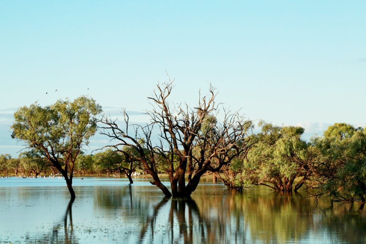
Totemic ancestors, including the ancestral dogs which travelled near Ali Curung, are believed to have created the landscape in their travels. The dogs that visited this area created the shallow watercourses and flood plains in this region.
Two important sites (dog dreaming sites) are within close proximity (6km) of the community. Ali Curung has adopted the dog as its official emblem to signify the importance of the ceremonial story. The emblem appears on all official Council correspondence and letterheads and on the Council seal. Due to their relationship to the ancestral stories and sacred sites in the area, all dogs are regarded as extremely important.
History
During the late 1950s, small groups of people were collected from around the region and relocated to Warrabri Settlement. These included Kaytetye people from Barrow Creek, Warlpiri people from Bullocky Creek areas and Alyawarra people from Murray Downs and Hatches Creek. Over 1,200 people populated Ali Curung in its early days. Warrabri was established in 1956 under its original name of ‘Warrabri Settlement’. The community changed its name to Ali Curung in 1978.
Services
Barkly Regional Council service centre, Warrabri Bakery, Minnirri Store, police station, safe house, Homemakers, Aged Care Service, Arlpwe Art Centre and Gallery, Baptist Church, health centre and a mechanical workshop.
Warrabri Bakery
Established by Mick Tsavaris in 1979 to provide fresh bread to the community daily, the bakery is still operated by the Tsarvaris family.
Minnirri Store
The original stored opened in the late 1960s as a community store providing food, merchandise and fuel. Currently managed by Outback Stores, the store is open Monday to Friday.
Arlpwe Art Gallery
Established by Arlpwe Artists Aboriginal Corporation on 30 June 2008, the centre currently employs 10 staff and sells Aboriginal artefacts such as boomerangs, nulla nulla, spears, jewellery, coolamons, and magnificent one-of-a-kind paintings by renowned artists of the area. The English translation of the Aboriginal word Arlpwe is "...this country all over, no waterhole, no rivers, only soakage and Spinifex country" (Mr Mick Waake).
Infrastructure
Ali Curung Advanced Water Treatment Plant opening in April 2013 and launch of Council water park in March 2016.
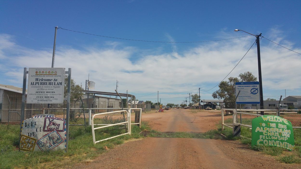
Alpurrurulam
List of Services
Council Contact
Mail : PMB 23 Mt Isa Queensland 4825
Local Authority
CHAIR:
Laney Tracker
DEPUTY CHAIR:
Jennifer Mahoney
APPOINTED MEMBERS:
Maria Turner, Charlie Larkins, Benjamin Olschewsky, Ashley Toby, Reggie Nelson, Marshall Teece
Alpurrurulam was taken from the traditional name of the lake now known as Lake Nash. LA Meetings are subject to change, so please call the Area Manager to check dates.
"We ask you to help us with your law. This is our final decision. We don’t need more meetings to talk about it. We will not change our minds. We are staying here in our place, Lake Nash.”
"You say you cannot help us while we stay here. But your government has the power in the Crown lands Act to get country for us here, a compulsory acquisition. The King Ranch has a big station here, over 8500 square km. We only need about one square km to stay here, on our long time home."
“This waterhole where we live was Aboriginal place long time before white man came. It was Aboriginal place before it became ‘pastoral lease’. It is business country for us. Our law does not change."
Excerpts taken from a letter written by the community to Chief Minister Paul Everingham, 6 December 1982 (Pg 129,
We are Staying │The Struggle for Land at Lake Nash │By Pamela Lyon and Michael Parsons)
Alpurrurulam lies on an important source of water in a dry country. Pastoralists called the place Lake Nash, but its Aboriginal name is Ilperrelhelame In the time of the Dreaming, great beings passed through that country: antyipere, the flying fox, nyemale, the grass rat, who partly formed the river and kwerrenye, the green snake.
Compared to other groups in the Barkly Tablelands contact with white people came relatively late. Until about 1920, the Alyawarre continued to live traditionally in relative peace, hunting emu and kangaroo and foraging over their country and enjoying a rich ceremonial life. That life was nearly extinguished during that era when Aborigines were randomly shot at or subject to drought, disease and hunger. Despite the cruel and violent past, Lake Nash was considered “good boss country” by Aboriginals and many went to work on the station there – a vital part of the cattle industry that later tried to displace them.
History
Alpurrururlam was formed out of a discord between Lake Nash Station and the Aboriginal population living on the nearby Georgina River. At the time many of the community members worked at Lake Nash Station but in the early 1980s there were plans to move the community to Bathurst Downs. For the locals this was “poison country”, no good to live on and posed a risk during wet season. They wanted to stay at Alpurrurulam – their home where there was water in the river all year round. In 1982 the community wrote to the then Chief Minister of the Northern Territory Government requesting a parcel of land to call their own near Lake Nash Station. After many legal battles, 10 square km area was excised from the pastoral lease and given back to the community in 1983. Alpurrurulam Land Aboriginal Corporation (ALAC) was then formed to be the land owner (a board of Community Elders) for the land. This is what is now called Alpurrurulam.
Services
Book AccommodationBarkly Regional Council Alpurrurulam Service Centre and municipal yards, Aged Care, Night Patrol, Sport and Recreation, Centrelink, Post Office, Warte Alparayetye community owned store, Alpurrurulam Community School (until Year 9), Rainbow Gateway – new community development program.
Infrastructure
Laundry construction - June 2014, road upgrades - June 2014, regional fencing - 2015.
Wind Farm
Three 15kW wind turbines were installed into the community in November 2011, producing about 12kW of electricity a day.
Solar Farm
A hybrid solar-diesel power system was also installed in 2011-2012. It has 1500 solar panels which produce 180kW of electricity a day. The system is integrated into the existing diesel power station, so when the solar drops off the diesel kicks in. Up to 80 per cent of the power used during the day in this community is supplied by either the sun or the wind. Alpurrurulam now has one of the lowest rates of diesel consumption in the Northern Territory.
Airport
Built in 2007, the runway is 1200m long by 22m wide. There are planes to Mt Isa for health appointments once a week with a special mail plane on Fridays.
Ampilatwatja
Council Contact
Mail : PMB 68 via Alice Springs NT 0872
Local Authority
CHAIR:
TO BE ELECTED
APPOINTED MEMBERS:
Tony Morton, Geoffrey Morton, Amaziah Club, Sean Peterson, Ellwyn Holmes, Ricky Holmes, Lulu Teece, Levina Morton, Richard Peterson
EX OFFICIO:
Mayor Sid Vashist
Pronounced (um-bludder-witch), this community lies in the heart of Alyawarr country on the Sandover Highway. LA Meetings are subject to change, so please call the Area Manager to check dates.
"I too have a dream – I still got hope don’t drink that coke and don’t light that smoke. Brother turn the sound up, culture hold the ground up. Listen to the spirit in the wind singin around us … Go to school, learn my culture – how to sing my song. Be a dreamer, a leader and live life long. Sing along with the people of the Alyawarr Nations. ‘Coz change gunna come with this generation!” Extract taken from Fly Back Home, The Desert Sevenz, The Alyawarr Sessions 2013
“Nantera Alywarr ngerra (we are all Alyawarr people). Nantera kultura dompenamati (learn from the old people) Awillichek dompenamati (listen to the old people) Dompenamati (old people)” Extract taken from 2Wayz, The Desert Sevenz, The Alyawarr Sessions 2013
“We never moved from this country. This is our father’s father’s country. We can’t leave it.” Banjo Morton
Ampilatwatja is in the heart of Alyawarr country on the Sandover Highway. The Alyawarr people have always lived there and would travel between soaks (water sources) in the hot weather. The people of this region also have close ties to the people who live at Alpurrurulam, and early in the days of European settlement they would walk to Alpurrurulam to collect rations of food and tobacco. In the 1990s, with the return of Utopia Station to traditional ownership, the Alyawarr people of Ampilatwatja made a claim for their traditional homelands.
Ampilatwatja is the cultural heartland of the Alyawarr nation with art an important expression of the Alyawarr people’s connection with the land. Local artists are said to “exude a complex and progressive approach to depicting the traditional knowledge of dreaming and country through the translation of water holes and soakages, bush medicines and bush tuckers, mountains, sand hills and ant hills”. Their artworks retain the heritage and feature the cultural history and values of Alyawarr lore
History
The first European in the region was Charles Winnecke, a surveyor, who passed through in 1877. Although the Alyawarr people were shy of the Europeans, Winnecke’s expedition needed the help of the local people to find water in the desert. Freehold title leases were granted by the federal government around 1910 to establish cattle stations on Alyawarr land in an attempt to bring white settlers and development to central Australia. Traditional owners lost rights to culturally significant sites and to hunting grounds to make way for the grazing cattle.
In 1940, the land around Ampilatwatja was taken up by settler John ‘Nugget’ Morton, who is connected to the Coniston Massacre of Aboriginal people in 1928. The resultant Ammaroo Station became a gathering place for Alyawarr people in the ‘60s and ‘70s where many worked as drovers and fencers. In 1976 under the Native Titles Act Alyawarr families were granted a small plot at an area then known as Honeymoon Bore, about 10km from Ammaroo Station. This small settlement is what has now developed into the community of Ampilatwatja. In the 1990s the traditional owners gained small excisions from the local pastoral lease to continue their life on the land.
Services
Barkly Regional Council service centre and municipal workshops, Aherrenge community store, Aged Care Service, Night Patrol, Ampilatwatja Health Centre Aboriginal Corporation, Ampilatwatja Health Centre, police station.
Infrastructure
Ampilatwatja Staff House, regional fencing, workforce development, local road improvement.
Artists of Ampilatwatja
The Community Art centre began in 1999 and artworks produced maintain a strong focus on Alyawarr lore, with a particular emphasis on the natural landscape. Most of the artists paint Arreth, which translates to ‘strong bush medicine’. The paintings pay homage to the significance and use of traditional bush medicine, allowing an insight into their community. The community of Ampilatwatja made a conscious decision not to paint ‘altyerr’ dreaming stories. The artists paint their country where those stories sit. The work produced by the artists is recognisably distinct from other Aboriginal artistic communities, due to the application of fine dots and the often bright and child-like figurative depiction of the land.
Airstrip
The 1200m long airstrip caters mainly for the Mail plan and Royal Flying Doctor Service. It is a day/night strip but closes during heavy rain.
Arlparra
List of Services
-
WardList Item 1
Alyawarr
-
Population
110 (Homelands Service Provider Rpt 2023)
-
Location
381.8km south-east of Tennant Creek
-
Road Conditions
Unsealed. During the wet season - December to March - the roads, the connecting Sandover highway and the river are often impassable. 20 km of the road is sealed bitumen from Arlparra north to Urapuntja health centre and the air strip.
-
Languages
Alywarr and Anmatyerre
Council Contact
Mail : PMB 127 via Alice Springs NT 0872
Local Authority
CHAIR:
Graham Long
APPOINTED MEMBERS:
Malcom
Loy, Joyce Jones, Kim Riley, Esau Nelson, Allen Kunoth, Shane Loy, Michelle Stacey , Jack Clubb
EX OFFICIO:
Mayor Sid Vashist
A land rich in Aboriginal culture, languages and lore, Arlparra has an abundance of bush-tucker and world famous artwork. LA Meetings are subject to change, so please call the Area Manager to check dates.
“So that’s the message, very strong. We will not stop being Aboriginal people, with our language, with our rituals, through our rituals our responsibilities to the land, and furthermore, holding that land as the underpinning of everything we are.”
Statement from TO in Arlparra/Utopia [This is What We Said: Australian Aboriginal People Give Their Views on the Intervention]
The homelands movement began in the late 1960s and gained momentum through the 1970s and 1980s. Small Aboriginal groups - often families or other closely related people - left larger communities and relocated on (or closer to) their traditional land. Homelands allow Aboriginal people to gather traditional foods and be close to sacred sites, burial places and dreaming trails.
The Utopia homelands are one of the more established homelands in the NT, comprising of 16 dispersed communities. These communities are separated by rough, corrugated dirt roads and in some cases by the dry and sandy river bed of the Sandover River. The most central community is Arlparra, on the eastern perimeter of the Western Desert adjacent to the traditional land of the Eastern Anmatyarre and Alyawarre people.
History
Named by German settlers in the early 1920s, Utopia was a pastoral lease owned by the Chalmers family. Aboriginal people originally lived close to the main homestead area now known as Three Bores Homeland. The property was sold and became alienated Crown land held on behalf of Aboriginal people. After a lengthy land claim hearing, this land legally became known as the Angarapa Aboriginal Land Trust under the Aboriginal Land Rights (NT) Act 1976. Aboriginal families then moved back to their more traditional areas.
Services
Barkly Regional Council Arlparra Service Centre, Arlparra General Store, Primary School, High School, general store, Urapuntja Aboriginal Corporation and Urapuntja Health Clinic (10km north of Arlparra).
Infrastructure
Arlparra Service Centre upgrade – May 2014, Arlparra playground upgrade - 2014, Utopia septic system upgrade – 2014, water tanks at Rocket range, Anterrengeny, Kurrajong, landfill construction, new police station construction, Utopia homelands water infrastructure for Pungalindum and Urapuntja clinic, workforce development.
Art Scene
During the late 1980’s the Aboriginal people of Utopia started to put acrylic paint on canvas. This followed a very successful decade of working with batik, several years after the Papunya art movement began. Utopia artists were initially quite formal in their painting techniques with fairly large dot or linear work. It didn’t take long, however, before many artists became bolder in style, colour and flair. This is what the contemporary art of Utopia is renowned for today.
Airstrip
This small runway is situated close to the Urapuntja Health clinic at Urapuntja (Amengernternenh)
Power
240 volt power is generated from Arlparra to supply all homelands, including Irrultja and Ampilatwatja.
Water
Water is provided to most communities through bores and stored in ground and elevated tanks. Barkly Regional Council transports water to the communities without bores.
Elliott
Council Contact
Mail : C/- Post Office Elliott NT 0862.
Local Authority
CHAIR:
TO BE ELECTED
DEPUTY CHAIR:
Jodie Nish
APPOINTED MEMBERS:
Jason Mullan, Kevin Gaskin, Kevin Neade, Lora Jackson, Kaye Dalywaters
Smack bang in the middle of the Northern Territory, along the Stuart Highway, lays the small township of Elliott. LA Meetings are subject to change, so please call the Area Manager to check dates.
“Since we got local government there have always been Aboriginal people on the council. They have special links into the community and they see both sides of the story. I think they have shown the way toward black and white people doing things together. We have worked together to achieve a very good compromise arrangement, by consent, whereby native title has been granted to more than 80% of the land in Elliott. That has helped confirm the recognition of Elliott as a place that has rich mythological significance for Aboriginal people. At the same time, European heritage has been recognised with the heritage listing of Newcastle Waters town, and that has now become a major visitor attraction.”
— Councillor Bob Bagnall, 2010
The traditional name for the township of Elliott is Kulumindini. It is the country of the Jingili desert people with the Wambaya people to the east and south-east; the Yangman and Mangarrayi to the north; the Mudbura and Gurindji to the west and the Warlpiri, Warlmanpa and Warramungu to the south and south-west. These people all had traditional associations with the Jingili and ceremonial ties to the watered areas around Elliott. The lands around Elliott lie across the important Dreaming tracks of the Emu and the Sun, spirit ancestors who were travelling through country on their way to the southern parts of the Northern Territory. The rocks found in this area are amongst the oldest in central Australia, some over 1900 million years old.
The explorations of John McDouall Stuart who traversed the centre of Australia from south to north in the mid 1880s opened up the Northern Territory to white settlement. Yet, it was the decision to build the Overland Telegraph Line from 1870-1872 which gave the modern Northern Territory a reason to exist. Along with telegraph stations at Alice Springs, Tennant Creek, Katherine and Darwin one was situated at Powell Creek, about 60km south of Elliott. Elliott itself did not come into existence until 1942.
History
Elliott is the Barkly region’s second largest town and sits on the edge of Newcastle Waters Station. Named after Army Captain Reginald Douglas Elliott (MBE), it began life at the site of Number 8 bore as an Australian Army Camp during World War II (1942). A war memorial statue stands on the site of the camp, directly adjacent to the bore used to supply water to troops.
Its population is largely Aboriginal, who live in two outstations at either end of the town – Gurungu (North Camp) and Wilyuku (South Camp). Gurungu was formed in 1968 when workers left Newcastle Station following a dispute and Wilyuku started in the 1970s when people left the Barkly Tablelands after award wages were brought in.
Services
Barkly Regional Council service centre and workshop yards to service the communities of Wilyuku, Gurungu and Marlinja outstation, sport and recreation centre, aged care services, safe house, police station, BP, art centre, play group, library, post office, Elliott School, caravan park and community store.
Infrastructure
Aged Care Vehicle, Tractor Purchase, November 2013 –landfill completion; December 2015 - Elliott Water park launched
Local attractions
Nearby Lake Woods was once part of a huge freshwater basin, which dried up in the last Ice Age, around 23,000 years ago. During this period, the lake reduced in size from 5000 square km to its current 420 square km. Longreach Waterhole forms part of this lake and is an important breeding ground for many inland bird species and popular with tourists.

Tennant Creek
Council Contact
Mail : 41 Peko Road, Tennant Creek [PO Box 821 Tennant Creek 0861
Local Authority
CHAIR: TBC
DEPUTY CHAIR:
Nathanael Mills
APPOINTED MEMBERS: Lachlan Wilkins, Nathanael Mills, Lennart Holbrok, Lorraine Gibson, Russell O'Donnell, Cr. Pennie Cowin, Cr. Greg Marlow, Cr. Sharen Lake, Russ Cowin, Liza Wilson
EX OFFICIO:
Mayor Sid Vashist
This remote Northern Territory town has been shaped by Aboriginal culture, gold mining and pastoralism.
“The Patta Waramungu people were the first Indigenous group in Australia to negotiate a Consent Determination and Indigenous Land Use Agreement, which recognised their Native Title rights and interests within a Township. The Federal Court of Australia handed down the judgement on September 3rd, 2007.”
— Patta Aboriginal Corporation
Tennant Creek is a remote Northern Territory town shaped by Aboriginal culture, gold mining and pastoralism. The surrounding area is called the Barkly Tablelands, a region characterised by wide grassy plains, endless blue sky and massive cattle stations.
The traditional owners of the area surrounding Tennant Creek are the Waramungu people living on Patta land. Their culture is very much alive and well, with their stories showcased in the Nyinkka Nyunyu Art & Culture Centre. Nyinkka Nyunyu is an Aboriginal sacred site in Warumungu country. By chance the town of Tennant Creek grew up around the home of the spiky tailed goanna, a powerful Wirnkarra or ancestral being. The rocks are situated in the Nyinkka Nyunyu Art & Culture Centre next to the Stuart Highway which passes through the middle of the town.
History
European history in this area began in 1860 when explorer John McDouall Stuart passed this way on his unsuccessful first attempt to cross the continent from south to north. He named a creek to the north of town after John Tennant, a financier of the expedition and a pastoralist from Port Lincoln, South Australia.
Tennant Creek was the site of Australia’s last gold rush during the 1930s, and at that time was the third-largest gold producer in the country. The town was located 12 km south of the watercourse as the Overland Telegraph Station had been allocated on an 11 km reserve.
An important contributor to the early history of Tennant Creek was Mrs Weaber, wife of the blind owner of the Rising Sun Mine, one of the richest mines in the district before World War II. She set up the Christmas Tree event which still continues to this day. In 1940, the Weaber family sold Nobles Knob, which went on to become the largest open cut mine in Australia. It ceased production in 1985, and the last mine closed in 1999.
Services
Barkly Regional Council HQ and municipal depot
Infrastructure
Purkiss Reserve Skate Park - October 2014, Purkiss Reserve Football Change Rooms – July 2015, Tennant Creek Swimming Pool – November 2015, Tennant Creek Child Care Centre Grounds upgrade, Purkiss Reserve CCTV, Regional Economic Infrastructure.
Telegraph Station
The Overland Telegraph, which once linked Melbourne to London, was constructed in the 1870s and forged a corridor through the middle of the continent, which the Explorer’s Way and Ghan train now travel. A temporary building for a telegraph repeater station was erected near the watercourse of Tennant Creek, 11km north, of the town, in 1872.
Battery Hill Mining Centre
The town’s goldmining history is on display at the mining centre. Battery Hill, which overlooks the town of Tennant Creek, is also the site of one of the last two operating 10-head stamp batteries, a government-owned ore crushing machine.
Karlu Karlu (Devil’s Marbles)
This is the region’s most spectacular landmark with thousands of huge, precariously balanced boulders, about 114km south of Tennant Creek. The traditional Aboriginal people believe that these boulders are the eggs of the Rainbow Serpent from the Dreamtime.
Kunjarra (The Pebbles)
An outcrop of granite boulders, 11km north of Tennant Creek. They are called Kunjarra in Warumungu. Known as the smaller relatives of Karlu Karlu, the Pebbles are a sacred site.
Wutunugurra
List of Services
-
WardList Item 1
Alyawarr
-
Population
166 (Australian Census 2016)
-
Location
209.8km south-east of Tennant Creek on the north eastern edge of the Davenport Ranges 253.6km north of Tennant Creek
-
Road Conditions
Mixture of sealed and unsealed. Access to the community is variable, depending on weather conditions.
-
Languages
Alywarr, some Warlpiri, some Kaiditji
Council Contact
Mail : PMB 148 via Alice Springs NT 0872
Local Authority
CHAIR:
Shirley Beasley
APPOINTED MEMBERS:
Julie Peterson, Nathaniel Peterson, Fiona Peterson, Tracy Peterson, Kaye Beasley, Annette Nungala, Ezra Casson, Cedric Price, Mark Peterson
Wutunugurra is a remote Aboriginal community on a pastoral excision of the local pastoral station. LA Meetings are subject to change, so please call the Area Manager to check dates.
“Learn from your grandmother – know your skin. Alyawarr culture – pride within. Pride in my people, pride in my land, pride in the red dirt, here where I stand. Gotta take that time, follow that track … Find ‘em sugar bag. Bring ‘em right back. Where the honeybees at? Healthy, sweet - bush tucker be the best thing to eat. Grandmother said make your mark, learn your culture – play your part. Paint your art – pass it on. Gotta keep this Alyawarr culture strong. This song goes out to us E-Girls, coming home on the bush bus. Long journey, long dirt road. Wutunugurra. Home sweet, home.”
Extract from the song Wutunugurra by E Girls, The Alyawarr Sessions, 2013
Located on the north-eastern edge of the Davenport Ranges and the eastern side of the Frew River, Wutungurra is set in an arid landscape that is criss-crossed with watercourses, rocky hills, barren outcrops and valleys. When the land receives significant rain it transforms into a vibrant escarpment, set against the hues of trees, rocks and hills. At these times the waterholes connect and spill across the country. Wutunugurra itself was named after a large waterhole next to Epenarra homestead, about 2km away. Their dreaming is Rain Dreaming.
History
Wutunugurra (Epenarra ) is a Community Living Area (CLA) sitting on 99ha, which was excised from Epenarra Pastoral Lease in the early 1980’s. The Clough family have held the lease since 1952 and enabled a small portion of Epenarra Station to be returned to the traditional custodians as a living area. A handful of the TOs living today still speak of the ration days in the 1960s when many of the families moved back to Hatches Creek where there was a wolfram mine. Wolfram is an ore from which miners get Tungsten, a metal used for hardening the tips of drills among other things. The Aboriginal people went to work with the other tribes. They filled up bags and sent the mineral away on the train to Alice Springs. The largest mine, the Pioneer mine, operated up until 1970.
Julalikari Council Aboriginal Corporation (JCAC) was the service provider for Wutunugurra until February 2009 when the Barkly Regional Council became the primary service provider.
Services
Barkly Regional Council Wutunugurra service centre and municipal work yards, Epenarra School (Barkly Group School), health clinic, Aged Care Service, Night Patrol, Outback community store
Infrastructure
Improvement of local road infrastructure and equipping of a new production bore to secure water supply, and the upgrade and extension of the rising main (approximately 3000m).
Local attractions
Old Policeman’s Waterhole, around 45km past Wutunugurra, and Whistleduck Creek, just past Kurundi Station.
Artists
The women of Wutunugurra are accomplished artists whose paintings reveal their unique bond to the land with depictions of bush tucker, bush medicine, their hunting grounds and waterholes of ancestral country. They have also experienced the complete transformation of Aboriginal society, from elders who led a nomadic existence to the first meetings with white people, the mission era, the stolen generation and the younger people who now experience both traditional culture and the modern world and are creating a new dialogue with music to bridge the gap. Some of the art produced within the community has been sold right throughout Australia.
Airstrip
Private strip owned by Epenarra Station; day time only. Another airstrip based in the community of Owairtilla (Canteen Creek), 60km away. Access is via air charter services only.